 Geozip 1
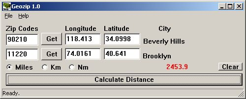
Geozip calculates distance between US (optionally Canadian) zip codes or geographical coordinates. You can choose miles, kilometers or nautical miles output.
Last update
22 Feb. 2007
Licence
Free to try |
$49.00
OS Support
Windows
Downloads
Total: 702 | Last week: 3
Ranking
#2083 in
Applications
Publisher
Island Limited
Screenshots of Geozip
Geozip Editor's Review
'Geozip' is a simple program, which allows you to calculate distances across United States according to ZIP codes.Using the program is quite simple. You enter the ZIP codes of the start and end locations and the program will calculate the distance between them. It also displays the coordinates (longitude and latitude) of that ZIP code. The distances can be displayed in miles, kilometers, or something else, which I believe to be nautical miles.
Pluses:
Drawbacks / flaws: It only calculated distances between US ZIP codes and nothing else. In addition, you can calculate distances between two locations by using Google Earth, which is free.
In conclusion: I found the program too expensive, compared to what it's designed to do.
version reviewed: 1.0
Geozip Publisher's Description
Geozip calculates distance between US (optionally Canadian) zip codes or geographical coordinates, latitude and longitude. It does take into account the curvature of the earth for calculating. You can choose miles, kilometers or nautical miles output. Customixation is available if you need more specific applications using the Geozip geographical distance...
Read moreLook for Similar Items by Category
Feedback
- If you need help or have a question, contact us
- Would you like to update this product info?
- Is there any feedback you would like to provide? Click here
Popular Downloads
-
 Athan
4.5
-
 Kundli
4.5
-
 Hill Climb Racing
1.0
-
 Cool Edit Pro
2.1.3097.0
-
 Macromedia Flash 8
8.0
-
 Grand Theft Auto: Vice City
1.0
-
 Grand Auto Adventure
1.0
-
 Cheat Engine
6.8.1
-
 Iggle Pop
1.0
-
 Tom VPN
2.2.8
-
 Vector on PC
1.0
-
 Ulead Video Studio Plus
11
-
 Zuma Deluxe
1.0
-
 MKV Player
2.1.23
-
 Netcut
2.1.4
-
 Windows XP Service Pack 3
Build...
-
 Minecraft
1.10.2
-
 Horizon
2.9.0.0
-
 Microsoft Office 2010
Service...
-
 Auto-Tune Evo VST
6.0.9.2


